- Examination of Numerical Simulation Model on Powder Snow Avalanches
- Numerical study for near shore currents and deformation of topography using multi-directional irregular wave simulation
- Analysis of Developing Snowdrift Using k-É√Turbulence Model
- Numerical Simulation of Overland Flood Flow with Fine Geographical Information of Landform
- Comparison of Velocity Vectors Measured by Image Analysis to Numerical Calculation of Inclined Wall Thermals
- Numerical Study for Flow Fields Around Moving Bodies Using the Rectangular Eulergrid System
- Numerical Simulation of the Wave Runup with a Fine Geographical Information around a Coastal Area
- Experimental Study on Velocity Fields and Dynamic Characteristics of Inclined Wall Thermals
- Exploitation of the Simulation model as Current in the Sea Area of Coast
- A Numerical Study on Three-Dimensional Tidal Simulation in Hiroshima Bay
- Numerical Study on Production of Sea Salt Spray

Summary of Master & Bechelor Theses 2002.3
[ English ] [ Japanese ]
Masahiko ASANO
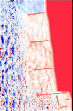
About 70% of the country in Japan is forestry and mountainous area where villages and structures are also located. Thus, these areas have potential damages to natural disasters by powder snow avalanches in severe winter. In order to prevent such natural disasters, the development of the simulation model for powder snow avalanches is necessary. Using such model, we can draw a hazard map of powder snow avalanches. In this study, the avalanche simulator based on the numerical model developed by Fukushima is developed and is applied to the Maseguchi avalanche which occurred in 1986 in Niigata Prefecture, Japan. The avalanche simulator can calculate flow properties and draw several graphs, i.e. the variations of the travel speed, the maximum thickness, the concentration of snow particles and the snow mass in time and space, etc. The simulation model has several parameters, i.e. the entrainment coefficients of air and snow particles, the drag coefficient and the friction coefficients on the upper and lower boundaries of an avalanche in addition to several shape factors which describe the shape of an avalanche. These values can be selected as the parameters in the avalanche simulator. Thus the identification of the model parameters is possible using the simulator.
 Hiroyosi KABASAWA
In recent years, coastal structures are more huge and sophisticated. It is very important to estimate influence of such structures to coastal environment. Waves, which are multi-directional and irregular by itself, near shore currents and deformation of bottom topography are connected very complicatedly. However, the numerical methods to understand the interaction of wave are not fully established. In this study, a series of numerical simulations with multi-directional wave are carried out to understand each process. Numerical results for near shore currents and deformation of topography which affected by configuration of coastal structures, agree well with knowledge obtained previously.
 Takuro KIKUCHI
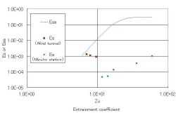
The numerical analysis of snowdrifts in a developing region was carried out using the k-É√
turbulence model. This model consists of the mass conservation equations of air and snow
particles, the equations of momentum in two directions, the equations of kinetic energy of
turbulence and viscous dissipation rate of turbulence. The partial differential equations are
discredited by the SIMPLE method.
The numerical calculation of the developing snowdrift is carried out. The numerical results
of profiles of wind velocities and flux of snow particle are compared to the experimental results
obtained using the low temperature wind tunnel in Shinjo Branch of Snow and Ice studies
NIED, and the observation tower of 30m high in Mizuho station, Antarctica. The numerical
model using the k-É√ turbulence model explains well the characteristics of snowdrift. Functional
form of an entrainment coefficient of snow particles was discussed comparing with the functional
relationship of the entrainment coefficient of sand particle from the bed.
 Ayami SAKAI
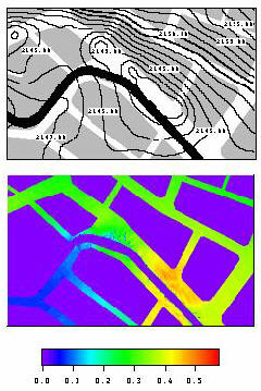
In these years, in Japan overland flood disaster often occurs in summer, which the Japanese Islands has
heavy rainfalls by seasonal meteorological front. Especially the urban areas with some small creeks are faced
to danger of the flood. Each municipal office opened the hazard map, which shows each point is safe or not
against flood, to public. The hazard map should be more fine and accurate.
In this study, new algorithm is introduced to obtain fine geographical information of landform, such are
fine altitude and land use. Model area is urban area of Nagaoka city, where the Kaki River runs through it.
In Nagaoka municipal office, the altitude data of manhole top is kept. The resolution of the data is 1cm,
which is fine enough to focus altitude of flat urban area. A series of numerical simulation of the shallow
water equation with the fine geographical information are carried out. Numerical results are satisfactory
qualitatively.
 Masanori TAKAGI
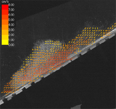
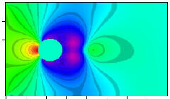
Inclined wall thermals are a typical example of gravity currents. The gravity currents are divided into two; conservative ones and non-conservative ones. Negative buoyancy is kept constant in the travel direction in case of a conservative gravity current. On the other hand, negative buoyancy changes in the travel direction in a non-conservative gravity current. The saline thermal belongs to the conservative one. The particle gravity current belongs to the non-conservative one. The objectives of this study are (1) to investigate the flow properties of the conservative inclined thermals by experiments, (2) to obtain the velocity vectors using the image processor, and (3) to compare the experimental results to the results of velocity field by the numerical analysis. Also, the experimental results of the travel speed and the maximum thickness are compared with the numerical results. The numerical model is based on the k-É√ turbulence model and the SIMPLE model to discretize the partial differential equations. Those experimental results are explained by the numerical results. Three typical velocity vectors are found out, i.e. the roll up vectors in the front region, the strong vectors in the travel direction and the entrained vectors in the back region.
 Akihiro TSUDA
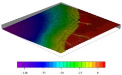
In late years, Computational Fluid Dynamics has been advanced by improvement of computational technology Almost all of the numerical studies for flows are done just for the around the body at rest. It is very difficult to calculate flows around a moving body even if the curvilinear coordinate is adopted. In the field of civil engineering, examples of the motion of obstacles affected by flow field surrounding the body are 1) moving body in a field such as human body or woods, 2) a bridge affected by the aerodynamic drag. Numerical scheme that can treats interaction between a moving body and flows are of grate use for civil engineers who concern such a problem. In this study, a numerical code that can calculate body and flow interaction is suggested newly. A series of numerical experiments which are 1) body at rest, 2) rotating body, 3) moving body affected by hydrodynamic, are carried out. The calculated flow field for a body at rest shows vortex pattern at low Reynolds number, which agree well with the previous study. Flow fields around a moving body and moving body affected by flows are quite reasonable.
 Keiji HANABUSA
It is well known that natural disasters by the wave runup, such as tsunami and storm surge may cause devastating damage to the coastal area. In Japan, counter measurements against the coastal disaster have been taken since the typhoon of Ise-Bay in 1959. However, the coastal disaster still occurs because waves that have larger wave height than the design wave sometimes hit the coast. It is very important for the hazard maps to be opened to the public to inform them with endangered area in case of disaster. To improve the accuracy of the hazard map, more precise geographical information such as small creeks, river mouth and/or configuration of maritime structure should be taken in to consideration. In this study, a series of numerical simulation of wave runup with a fine geographical information around a coastal area is conducted. Niigata area ,which is located on Japan sea side of the Honsyu in Japan is taken for an example. Characteristics of wave runup affected by incident wave direc
Masato ENOMOTO
Inclined wall thermals are often observed in nature, i.e. powder snow avalanches, pyroclastic flow, and turbidity currents in coastal area. Experiments on inclined wall thermals are carried out in this study. The saline water is released from the upstream of the water tank into the body of fresh water. The saline water forms the inclined wall thermal. The travel speed and the maximum thickness of the saline thermals are measured using video cameras. The velocity vectors of thermals are measured using videotaped motions of the inclined thermals. Next, the numerical analysis of the inclined thermals is carried out. The numerical model is based on the thermal model using the continuity, and the momentum equations for the inclined wall thermals. The model explained well the experimental results of the inclined thermals. The observed velocity vectors roughly explained the velocity field of the inclined thermals.
Yasuo KISHINO
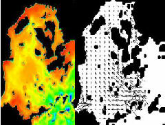
Environmental problem is interested by the people, in the sea area that is contaminationing by the many kind of chemical matter. The purpose in this study,exploitation of the simulation model as current for on the assumption that will be use for understanding the spread polluting matter.Six types of model are set up in calculate domain to compare the characteristics of ingredient in the water,and velocity of the water.It becomes possible to understand process change ingredient of the sea and velocity of the water in the passage of the times. We have three subjects main again,first calculate in the big scale in the time. Next, calculate take in the change of the place density by the heat flax. Third,compare the results of the calculation with the results of inspection of the scene.
 Makoto NAMAMURA
The knowledge of tidal exchange out of a stagnant bay is often required in understanding
the behavior of the water pollutant. Hiroshima Bay is the one of the famous stagnant
bay that is located the deep inside the Seto Inland Sea, Japan. The tidal flow is prevalent
in this domain because of the large tidal range. Therefore, it is very important to understand
the mechanisms of the tidal flow and the tidal residual flow for the water pollutant problem
in this domain.
This study simulated the tidal flow and tidal residual flow in Hiroshima Bay by using the
Three-Dimensional Flow Model. These results were compared with the some observed data.
Fuminori YAMADA
Sea salt spray is the small particle of seawater, splashed up by wind and wave action. A Sea salt spray, transported by wind, gives damage to structures which face directly to the sea, because the spray contains salinity. Particularly, many buildings are damaged severely by the sea salt spray. Many civil engineers especially structural on material engineers are life of the structure influenced by sea salt spray. In this study, integrated numerical code which covers 1) wave simulation with wave breaking 2) generation of see salt spray flux in the surface 3) advance-diffusion of sea salt spray, is developed. The wave breaking around coastal structure and shoreline are shown clearly.
| Copyright, |
Hydraulic Engineering Laboratory Department of Environmental and Civil Engineering NAGAOKA University of Technology |
