- Calculation of Wind profiles and Numerical Simulation of Snow Particle Motions Using k-Ć Turbulence Model
- Modeling of Pyroclastic Flow and Powder Snow Avalanches Considering 3-Dimensional Topography and Development of Numerical Simulator
- Numerical Experiment for Behavior of Flood Flow with Fine Geographical Information
- A Numerical Wave Simulation for Deformation of Bottom Topography
- A Study on the Vertical Profile of the Wind-driven Current affected by Long Shoreline
- Characteristics of wave induced by sudden lateral momentum intrusion
- Experiment on Density Interflow Intruding into Body of Two Layer Stratified Environment

Summary of Master & Bechelor Theses 2003.3
[ English ] [ Japanese ]
 Hiroshi ANDO
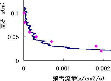
The simulation of snow particles motions is carried out based on the k-Ć turbulence model. The motions of snow particles in air are divided into three, i.e. the surface creep, the saltation and the suspension. The splash process which determines the impact and the ejection of snow particles on the snow surface is introduced in the simulation model. The values of the density of particles are estimated in the two-dimensional simulation. The calculated distribution of snow particles in the vertical direction is compared with the field observational results at the Mizuho station in Antarctica.
 Norihito OOSAWA
Large part of country in Japan is mountains area. Many villages and large structures have the potential of damage by pyroclastic flow or powder snow avalanche. In order to prevent these disaster, the understandings on characteristic of pyroclastic flow and powder snow avalanche are necessary. A hazard map can be made based on such knowledge. Also, the constructions of facilities preventing these disasters are possible.
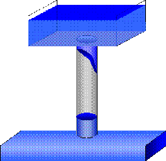
The flow mechanisms of pyroclastic flows and powder snow avalanches are similar to the thermal flow on the inclined boundaries. The models and the numerical simulator on such flows are developed considering the three dimensional topography. These models were originally proposed by Fukushima (1986). This numerical simulator can analyze the route of flow and lateral spreads of pyroclastic flows and powder snow avalanches in addition to the travel speed, the concentration of particles, the kinetic energy of turbulence. The simulator for the pyroclastic flows and powder snow avalanches on the three dimensional topography can estimate the actual behaviors of these flows.
 Hiromi KANO
In recent years, many of the floods which have happened in urban area have affected serious damages. To show a hazard map is suggested as the effective strategy for these disaster.
However, there are some technological problems about flood flow simulation; the grid size is too large to express the overflow of river which is small-size to medium-size, and it is no considered about an overflow occurred inside a bank.
Overland flood flow model has been already developed separately. The main purpose of this study is to develop an overland flood flow model considering the flow of drainage channel.
The first half, this study introduces the new algorithm about the flow of drainage channel. And the calculation is tried for imaginary drainage channel. The second half, it combined the two models (the overland flood flow model and the flow model of drainage channel) and tried to calculate.
Finally, by using this new model, a flow of drainage channel can be reflected in the numerical simulation of overland flood flow.
 Makoto KAWABE
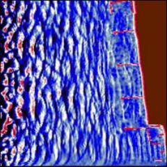
From a long time ago, Niigata prefecture is suffering from shore deformation and coastal erosion, mainly caused by wave induced currents. Countermeasures against these problems had been taken. To make such a countermeasure more effective, numerical simulation technique for waves, currents and shore deformation should be established. In this study, numerical wave simulation code with littoral drift is developed. The subject of the study is Niigata west coast. Numerical results for deformation of bottom topography with bottom sediment transport show qualitative agreement with knowledge obtained previously.
 Yoshiyuki KUDO
The west Florida continental shelf is referred as broad, gently sloping topography that extends approximately 200km from the coast to the shelf break, while, in this region, the seasonal wind forcing is considered to influence on the waters over the shelf. It is believed that most of the ocean's biological primary productivity takes place in continental-shelf waters, so that the shelf velocity field and mixing can play an important role to this productivity.
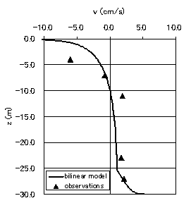
In this study, wind-driven current profile at west Florida shelf is analyzed by using a steady, linear, unstratified, two-dimensional model. Prior to introducing to the Florida shelf topography, two different types of the eddy viscosity profiles are examined. They are a constant(Ekman 1905) and a bilinear profile (Madsen 1977). Bilinear model results are compared with situ observed data at Northern California shelf to give a good agreement. Found that the bilinear model is safe to be introduced to the shelf region, wind-driven current on the Florida shelf is computed. Simple cross-shelf circulation patterns at the west Florida shelf due to the seasonal wind forcing are revealed.
 Hidekazu@OOKUBO
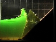
Tsnami is mainly generated by vertical deformation of sea bottom. Many numerical studies for tsunami have been done by making use of the fault model, which determines initial vertical displacement of water surface. However, tsunami may occur if landslides or debris flow intrude to the sea. In this study, a series of laboratory experiments have been carried out to investigate fundamental characteristics of waves which is induced by sudden lateral momentum intrusion. Numerical wave simulation with boundary horizontal momentum intrusion is also carried out. Wave profile changes with the shape and weight of the wooden model. Results of numerical wave simulation agree with experimental results qualitatively.
 Yuya Yamaguchi
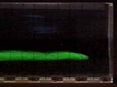
The experiments on the density interflow intruding into the body of two layer stratified environment. The fresh water is used for the water of the upper layer. The saline water is used for the water of the lower layer. The travel speed of the front and the maximum thickness are measured in the experiment. In the case that the relative density difference of the two layer is small, the travel speed is small and the maximum thickness of the interflow is large. On the contrary, in the case that the relative density difference is large, the travel speed is large and the maximum thickness of the interflow is small. The experimental results of the travel speed are compared with the theoretical equation found by Kao. It is found that the experimental data are larger side of Kaofs equation. The reasons may be the effect of the mixing of the inflow water and surrounding water, the viscosity of the water and the existence of the mixing zone between the two layers.
| Copyright, |
Hydraulic Engineering Laboratory Department of Environmental and Civil Engineering NAGAOKA University of Technology |
